Spaces:
Sleeping

Sleeping
File size: 2,026 Bytes
980dc8d |
1 2 3 4 5 6 7 8 9 10 11 12 13 14 15 16 17 18 19 20 21 22 23 24 25 26 27 28 29 30 31 32 33 34 |
---
title: "Geospatial Analysis with Python"
original_url: "https://tds.s-anand.net/#/geospatial-analysis-with-python?id=geospatial-analysis-with-python"
downloaded_at: "2025-06-08T23:22:52.295346"
---
[Geospatial Analysis with Python](#/geospatial-analysis-with-python?id=geospatial-analysis-with-python)
-------------------------------------------------------------------------------------------------------
[](https://youtu.be/m_qayAJt-yE)
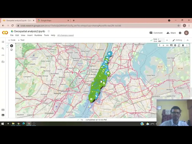
You’ll learn how to perform geospatial analysis for location-based decision making, covering:
* **Distance Calculation**: Compute distances between various store locations and a reference point, such as the Empire State Building.
* **Data Visualization**: Visualize store locations on a map using Python libraries like Folium.
* **Store Density Analysis**: Determine the number of stores within a specified radius.
* **Proximity Analysis**: Identify the closest and farthest stores from a specific location.
* **Decision Making**: Use geospatial data to assess whether opening a new store is feasible based on existing store distribution.
Here are links used in the video:
* [Jupyter Notebook](https://colab.research.google.com/drive/1TwKw2pQ9XKSdTUUsTq_ulw7rb-xVhays?usp=sharing)
* Learn about the [`pandas` package](https://pandas.pydata.org/pandas-docs/stable/user_guide/10min.html) and [video](https://youtu.be/vmEHCJofslg)
* Learn about the [`numpy` package](https://numpy.org/doc/stable/user/whatisnumpy.html) and [video](https://youtu.be/8JfDAm9y_7s)
* Learn about the [`folium` package](https://python-visualization.github.io/folium/latest/) and [video](https://youtu.be/t9Ed5QyO7qY)
* Learn about the [`geopy` package](https://pypi.org/project/geopy/) and [video](https://youtu.be/3jj_5kVmPLs)
[Previous
Geospatial Analysis with Excel](#/geospatial-analysis-with-excel)
[Next
Geospatial Analysis with QGIS](#/geospatial-analysis-with-qgis) |